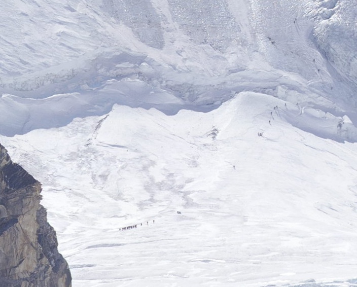
Looks like there's a few on the icefall. Follow the line of garbage, then up and across the fall. The only hard part is dealing with the inverted mouse movement on the interface. Why would they do that???
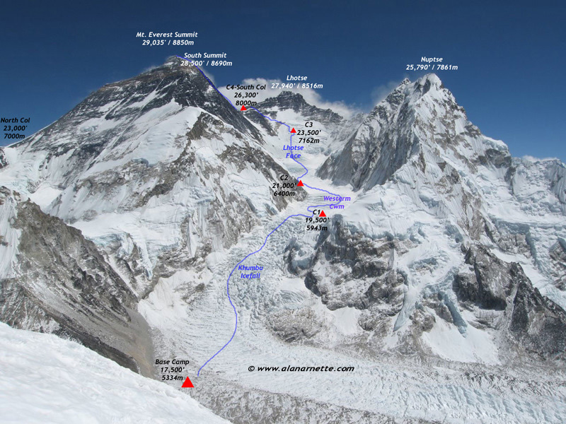
1. Of the 3 mountains, look at the peak of the center one (Lhotse).
2. Below that, the right half is big chunky snow, and the left half is smooth, icey looking snow.
3. Look at the line where the smooth left half meets the chunky right half. - Halfway up that you can find CAMP 3. [You'll see little ant people marching up that centerline - follow them to their tents.]
Also once you see CAMP 3, you actually see tracks in the snow. There's a manmade line going diagonally up/left across the center mountain, up the rock face, and then continues up/left to the little snow valley where Everest hits Lhotse along the horizon line. I suppose somewhere around there is CAMP 4.
It is probably Kala Pathar (the most accessible point to view Mt. Everest from base camp to peak, according to Wikipedia [0]) since the photo was taken from Pumori.
You can also see a small tent city at the base of the on the grey part net to the ice flow at the bottom left of the. And some buildings on the right side of the image. But oddly no real roads, so I guess it's all air lifted in, or mule trains.
Nearest road to Kathmandu was (for me, in 2001) a 14-day walk. The airport at Lukla is about 7 days. Everything comes in by porter or by yak train. It's nearly 18,000 feet altitude. The mountain goes straight up another 2 miles vertical. This panorama is fantastic, but realize it's on extreme wide angle, almost fish-eye. The mountain seems to take up the whole sky.
Thanks for this explanation, I wouldn't have seen that part otherwise. At first I wasn't sure which peak you meant exactly, but once I picked the right one I found it.
None of those little ant people are really climbing though.
Also, the resolution should have been much more than a gigapixel to make that part more interesting :)
I immediately saw the HUGE tent camp in the front though.
    Climber fatality from attempts through 2006:
    http://www.adventurestats.com/tables/EverestAgeFat.shtml

    Suicide estimate from NIH:
    http://www.nimh.nih.gov/health/publications/suicide-in-the-us-statistics-and-prevention/index.shtml
Actually, Everest is considered as on the easier side for an eight-thousander [1]. Annapurna got %38 (2007 figures) [2] and K2 got %25 [3].
For some interesting discussion on Everest fatalities, try this one [4]. "No shortcuts to the top" by Ed Viesturs and the well known "Into thin air" by Jon Krakauer are two good books on the subject, if you want to read more.
Yup, I've read that. The account by the reporter from Outdoors (?) was extremely graphic in detail (but disputed by others in the party). Sad all around, but through those deaths came better regulation which has led to a 1:7 ration of attempts/deaths vs. 1:4 in previous years.
This is very good visualization. It brings out the fact that number of summits have exponentially increased by number of death only linearly and with very slight slop. This means w have gotten exponentially better at summiting over time.
And I suspect that suicide fatality rate isn't 100% correct either. It's hard to really tell, if someone really failed trying to commit suicide, or if they just 'attempted' to get more attention.
The best way for you, as a mere mortal, and not some semi-suicidal mountaineer to experience big mountains is to take the bus from Santiago,Chile to Mendoza, Argentina. The trip through the Andes is really awesome. Sometimes you'll see a mountain and have no idea how big it is and then at the very bottom you can just barely make out some ant size cows grazing. Looking down at the bottom of some of the switchbacks on that route is like looking out an airplane window.
You seemed to know that I'm from south america, creepy ;) (I'm from Uruguay). I'm going to be living in Austria for the next 6 months so I will have no shortage of mountains there!
Closer to 50 dozen, there are tents all around the bottom of the picture where the glacier thins out. I never realized how many people are actually climbing that mountain in any given season.
How did anyone ever figure out how to climb that thing before there were satellites or planes? I don't even see how they are getting from the base camp up past the broken up glacier area.
There are really an absurd number of people "climbing" it - literally, my sexagenarian neighbour told me that "some of the girls from my tennis club are doing it". It really nullifies the whole mystique of Everest of any meaning whatsoever, and is having a terrible effect on the natural beauty of the terrain.
(I'm not some mountaineering snob - I tire climbing hills for a decent toboggan run)
Let's not get too carried away. At the end of the 2010 climbing season, only 3142 people had ever reached the summit.
A lot of people go to Base Camp as tourists, but the numbers drop dramatically at each higher camp. There's probably a case to be made that Base Camp should be toned down.
There aren't that many people truly climbing the mountain.
What is the point of 'natural beauty' if there's no-one to appreciate it? There's all sorts of reasons to preserve wilderness, but 'keeping it looking pretty' as a reason to prevent travellers is not one of them.
Not sure if you fully realize the scope with which it's turning into a sort of Disneyland - people are climbing it in an endless convoy. I find it quite shocking. If you do, then I guess we just fundamentally disagree.
This is a dead thread, more or less, but I'm a bit embarrassed about this. For posterity:
The footage I've seen was indeed from (and up to) the basecamp. I was quite shocked at what I saw, but I obviously misremembered exactly what it was - the trail to the basecamp. I certainly did not think all those people were reaching the summit, but I did think they were going higher.
I feel like a bit of an idiot, and needed to get that off my chest.
Edmund Hillary wrote "High Adventure" about a year after his climb, and a it's a great description of just how things were done in those days! It's a very easy read too, in a boys-own-adventure style.
They walk up that thing, its called Khumbu icefall. Basically the valley glacier spilling out in slow motion. Its incredibly dangerous (as you probably surmise), even though its at the bottom. Since the ice is all cracked up, many people fall into the cracks. Believe the local sherpas do most of the work each year to find a safe route through that mess.
I can see the guys up there with a few tents, and a lot of tents below the rough patch of ice. But I can't see anyone in between or above the few tents between the peaks.
Does anyone know why? Is this photo taken early in the day so there there's no-one going for the summit yet? Or does the route to the summit go somewhere where the camera can't see?
It might help if you think of it as directing the camera instead of moving the image. When you click and drag left, you're telling the camera to look to the left.
I think it's just an artifact of pre-tablet era interaction design (not that this software was actually written all that long ago).
Nowadays it seems perfectly reasonable to imagine clicking and dragging the image around in order to pan -- I'm not confident that particular interaction would have even occurred to a lot of people a few years ago, though.
I would say: Pre Google Maps era. I find it perfectly intuitive to click and drag most online maps around, but it might have been weird the first time I encountered it.
For example, I still like to scroll down to go down in a web page, and get confused (and frustrated?) when I use the new mac mice which use the touch-screen/map type scrolling. However I'm quite sure that if I was a mac person, I'd get used to it fairly quickly.
Actually the controls are "non-inverted", pull down to look down. Inverted is when you pull down to look up. Non-inverted is now very popular. Most first person shooter games that ship today have non-inverted as the default. I generally find people about my age and older (30 somethings) prefer inverted, but younger people vastly prefer non-inverted.
I believe I mainly have things like flight simulators with inverted controls. But it kinda makes sense there too, since in a plane you pull back (= down) on the stick to go up.
There is a option on the controls at the bottom (2nd button from right - 4 arrows, called change control mode) to 'fix' the mouse navigation direction.
This photo really makes me appreciate the fractal geometry and self-similarity of natural formations. When looking at part of the image w/o any objects of known size for reference I lost all sense of proportion. Tiny "pebbles" were actually boulders, etc.
So this is a little off-topic, but I read an article the other week that i haven't been able to shake about the number of people that have died on Everest and whose bodies have never been retrieved (warning, morbid and slightly graphic):
Just a reminder that those little dots are people who are taking a very real risk by attempting to reach the summit. I'm not sure if I'm envious of their drive, or if I think they are absolutely crazy.
There are far deadlier mountains out there than Everest. I think the current death rate is around 5%. Annapurna has killed about 35% of the climbers that attempted.
It has gotten to the point where there are basically proven (about as much as you can for something so dangerous) methods of getting to the top.
"Into Thin Air" is a great book on the journey (the very bad , and the good) to the top.
I always thought about doing Everest if I could ever afford it. You know, one those idle "I'll do that someday thoughts" we all have.
Once I hit the "I could afford this" point I started researching Everest...read Into Thin Air, Dark Summit, No Shortcuts to the Top, etc., watched every documentary I could get my hands on, even talked with one of the climbers featured on the Discovery series that featured Russel Brice's company.
I've concluded that I'm not interested. I'm not interested in standing in line at the Second Step for hours while my body consumes itself and I burn through the scant amount of oxygen I have. I'm not interested in the very real risk that I may arrive back at Camp IV after a summit attempt to find my O2 and supplies stolen. I'm not interested in seeing the corpses, oxygen bottles, tents, and other detritus cluttering up the mountain.
I'm not condemning those who chose to go or those who help them get there, but I'm out: human behavior has made the idea of summiting Everest unappealing.
Mountaineering is a great time, but I agree with you about Everest. If you want to do something fun, challenging, and not quite so dangerous or commercialized check out climbing 14ers. Climbing all the ones in the state is a common past time in Colorado. They all have varying degrees of difficulty and depending the peak and time of year you may have a beautiful day climb completely alone.
I had no idea that stealing supplies was so common! I really only heard on it -- and was shocked -- while listening to this talk (about K2): http://www.youtube.com/watch?v=5zkC9IMQmYA
The headline is a bit linkbait-y. A total of about 233 people have died. The Khumbu Icefall at the bottom is one of the most dangerous stretches, since it moves, giant seracs can collapse, etc. Those who died there would probably have been recovered and given a decent burial, or be lost at the bottom of a crevasse. When someone dies and it's not feasible to bring them down, typically at some point someone would bring them off the main trail and give them a decent burial. Others fall into inaccessible locations. Still there are a few bodies that have become landmarks. A longer discussion I saw in response to that widely shared article - http://www.alanarnette.com/blog/2012/12/06/bodies-on-everest...
Oxygen bottles are not nearly the problem they used to be due to programs in the late 90s and on where companies paid Sherpas (and other climbers) for bringing empties back off the mountain. There's also been a concerted effort to pick up trash starting ~1990 (see: http://en.wikipedia.org/wiki/Earth_Day_20_International_Peac...)
Yeah, that's why I think my initial response was what it was. I knew that Everest gets trashed by the climbers (I don't actually know it, it's just one of those memes I've picked up on over time), so my initial impression when seeing the small brightly-colored objects in the picture was, of course, that is all that trash I've heard that gets left on the mountain.
I saw the /gigapans/ in the URL and googled for it, thinking it must be a super intelligent panoramic "image sticher"+"image viewer" written in flash - but found this: http://en.wikipedia.org/wiki/Gigapan
The founder of the company I work for (Lot18) actually climbed Everest - so after sending him the link to this, he dropped by and explained everything we were looking at - and outlining the paths and various dangers associated with the climb. It's quite an amazing story - and I found some slides related to his climb from 2009: http://www.slideshare.net/snooth/everest-2003-north-face-res...
The result of a project by David Breashears, who has already climbed the highest mountain in the world five times. He used old images of Everest and its glaciers and combined them with new ones.
The photo is part of a broader project called GlacierWorks by the mountaineer Breashears, who made the much-acclaimed IMAX documentary “Everest.”
Just spent like 25 minutes looking it over with my colleague at work. There is so much going on here, it's awesome. I was also very blown away by how big the camp at the bottom of the valley was. Most of those must be semi-permanent structures that the guides maintain. I couldn't imagine that is transient traffic. I think I remember seeing something on departures (or something) about a big festival that happens in this valley. Maybe that has some context here as well, but I have no idea. Great link!
Wow this is captivating, but panning with the mouse on a desktop is so frustrating, the image movement is opposite what I expect! (browsing on a desktop, Windows/Chrome)
There might be a couple of climbers on the left ridge of Everest, which I just read is the easier climb. If you look near the base of the ridge on the left, there is a strip of snow that starts going up the mountain. Follow the ridge up you will come across a little cloud puff rising up on the other side. Just beyond that point, you will see two super-tiny parallel specks that sort of look like they are leaning into the mountain.
Look for camp 3. You have to zoom all the way in, and look at where the rough snow meets the smooth snow. You'll see some super tiny yellow dots, those are the tents. The tiny black specks just to the left are climbers.
The sense of scale in the Himalayas is almost unfathomable.....
I'm amazed not by the mountain - but by the size of the camp in the valley. I knew a lot of people climbed Mt Everest, but that't practically a small city.
The GlacierWorks team (in cooperation with URC Ventures) also made a photo-realistic 3D model of the Himalayas using images that were captured using a helicopter.
Great picture! We are also a company based in Nepal where this picture is taken from. Our company name is after another peak - Manaslu, which is a 8th highest peak in the world. We do Ruby on Rails web development. http://www.manaslutech.com
Others will be able to fill in more detail as I'm just going off memory here, but I think this is taken from the Nepalese side.
The ice field just above Base Camp (which, wow, look at all those tents) is the Khumbu Icefall, which climbers must scale to en route to the South Col.
The view from Kala Patthar summit is pretty different angle, this picture must be taken from somewhere north of KP. I would guess it is from Pumori Advanced Base Camp.
This is simply breathtaking. I'm sure the app behind this is assembling tiles together, but does there exist a full-resolution image of this in a single piece?
I've tried to use my network inspector to figure out how to access the individual tiles, but no luck.
I really like the user experience and I am impressed by how fluid it runs on my computer. Much more fluid than Google maps.
You should add a collaborative tagging interface, where users can choose to point out certain parts.
Amazing. I was fortunate to travel out to Alaska a couple of years ago and do some glacier climbing and hiking. It was amazing, but pales in comparison to the vast, immense power of this photo. Awesome.
I read Into Thin Air, about the 1996 account by a reporter who was with the crew that lost 4 members. After poking around I saw someone saying the Sherpas will kick bodies in the crevasses and they wash out in the Spring. Sad, but with a rate of 1:4 before 1996, then 1:7 after on death ratios its gotten much better. However, it takes money/balls/stupidity to climb that thing.
The point is that the creation of that high-resolution image of Everest is a noteworthy technological achievement, and most people have never seen such a high quality photograph of our planet's highest mountain before.